

3D Visualization and Analysis (3DVA) allows project teams to visually articulate complex environmental datasets to activate key decisions, enabling faster, cheaper, and more effective remediation compared to 2D graphical analysis.
Assimilation of historical site datasets into a 3D visualization model helps bridge the gaps among consultants, clients, regulators, and the public by presenting easy-to-understand visualizations of complex site processes and treatment/cleanup plans. A well-developed 3D visualization model allows project teams to build confidence that site conditions are well understood and generates cost savings and efficiencies throughout the project life cycle by:
- Supporting consensus-building and collaborative problem-solving
- Visually identifying data gaps and reducing decision risk
- Optimizing sampling/treatment areas
- Visualizing and quantifying impacts of remedial actions
- Creating graphics and animations for project deliverables and litigation support
- Accelerating project closure
3DVA Service Areas
- Air Dispersion Model Visualization
- Drone Survey and Sampling Visualization
- Above-(BIM) and Below-Ground 3D Model Integration
- Brownfields Site Redevelopment Visualization
- Geophysical Visualization
- Tunnel and Subsurface Infrastructure Visualization
- Real-Time Incident Visualization via 3D SQL Database
- Gas Migration Investigations
- Geothermal Visualization
- Oil and Natural Gas Well Pad Visualization
- Conceptual Site Models
- Contaminant Transport Visualization
- Environmental Forensic Chemistry
- Green/Sustainable Remediation
- High-Resolution Site Characterization
- Environmental Sequence Stratigraphy
- Landfill Visualization
- Mass Flux/Mass Discharge
- PFAS and Emerging Contaminants
- Remedial Investigations/Feasibility Studies
- Remedial Design/Construction/O&M
- Dam/Impoundment Safety
- Mine Reclamation Project Visualization
- Aquifer and Water Supply
- Groundwater Model Development and Outputs
Resources

Video: Environmental 3D Visualization and Analysis Services
The video highlights how 3D Visualization and Analysis (3DVA) allows project teams to visually articulate complex environmental datasets to activate key decisions.
Flyer: 3D Visualization and Analysis Services
Learn how we assimilate historical site datasets into a 3D visualization model and create easy-to-understand visualizations of complex site processes and treatment/cleanup plans. Download our latest flyer.
Examples
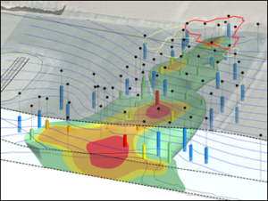
Hydrocarbon groundwater plume with potentiometric surface contours
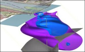
Nested groundwater plumes with topography, water table, and aquitard
